by Richard Florida
Earlier this week, Cornell mathematician Steven Strogatz reprised George Zipf's famous power law for the size distribution of cities where "the population of a city is, to a good approximation, inversely proportional to its rank."
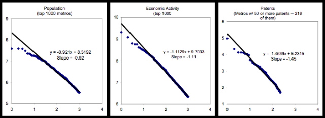
Tim Gulden of George Mason University has used data based on satellite images of the world at night to provide a Zipfian analysis for the 1000 largest urban agglomerations globally, based on several different measures of city size comparing rankings for population, economic activity, and patented innovations.
Gulden's research provides what is perhaps the first systematic depiction of the size distribution of global cities, and generates important insights into geographic organization of economic activity and innovation across the world.
While the population of cities tends to follow the Zipf law that Strogatz describes within a nation, this scaling does not hold for the whole collection of world cities. The distribution ends up being somewhat flatter - particularly among the largest cities. This may result from barriers to migration between countries.
The distribution of economic activity - which Gulden estimates using the light emissions from night-time satellite images - is more Zipf-like..
Innovation, however, appears to have a different scaling rule. The slope of -1.45 indicates that the distribution of patent activity is much more skew.
Gulden's work again reminds us that cities and urban agglomerations remain a key facet of globalization. As barriers come down and global forces continue to act on cities, the world's cities are likely to eventually conform to the basic rank-size pattern Zipf identified - already evident in the global distribution of economic activity and the even more skewed pattern of global innovation.The world's largest urban agglomerations are likely to become even bigger, while second and third tier cities face ever harsher competition.
